
Fremont County · Arkansas River Valley
Cañon City, Colorado
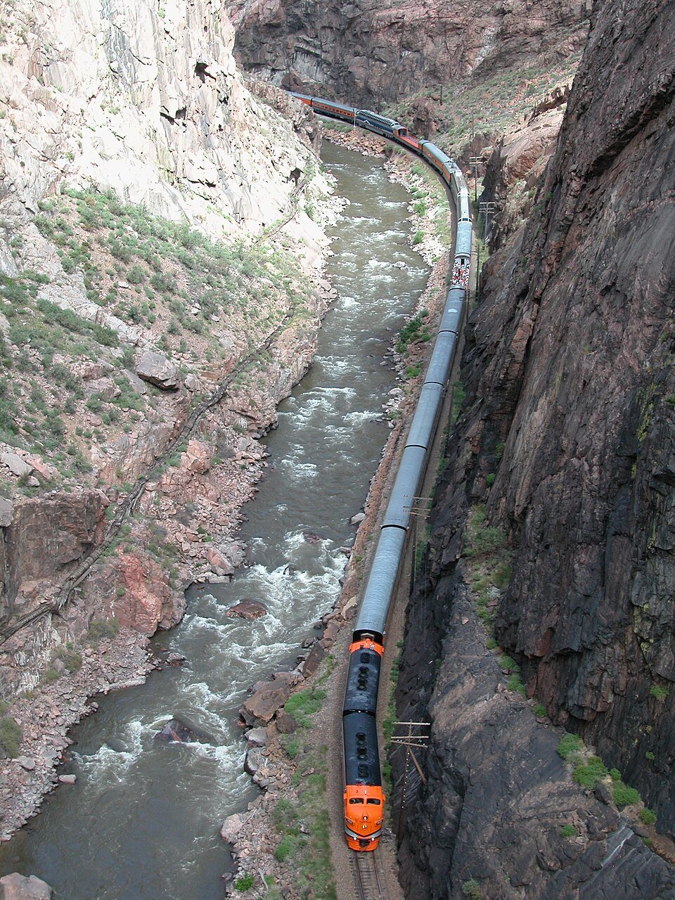
A train follows the Arkansas River through the bottom of the Royal Gorge. Nearly a thousand feet overhead, visitors walk the suspension bridge. Pick the view you came for, then leave time in Cañon City for the old prison cellhouse, the dinosaur tracks on Skyline Drive and dinner on Main Street.
Saved in this browser.


Photo credits
- Royal Gorge Bridge west of Cañon City · Open Road Colorado media
- The Royal Gorge near Cañon City · Open Road Colorado media
- Skyline Drive on the hogback · Jeffrey Beall · Source and license
- County
- Fremont CountySouth-central Colorado
- Town elevation
- About 5,330 feetArkansas River Valley
- Main route
- US 50Runs through downtown
- Royal Gorge
- Rail or rimDowntown depot or north-rim park
Choose your stops
Fun things to do in Cañon City, Colorado
Book the train or raft trip first if you have a departure time. The prison museum and Main Street fit together downtown. Skyline Drive and Tunnel Drive each have their own entrance west of town.
 All year
Royal Gorge Route Railroad
Board at the Santa Fe Depot for a round trip beside the Arkansas River. The canyon narrows until the rails, rapids and granite walls share a strip of riverbank.
The image is a historic railway postcard. For today’s ride, choose your car and check in at 401 Water Street. Allow the hour the railroad requests before boarding.
Plan your visit All year
Royal Gorge Bridge & Park
Walk the suspension bridge from rim to rim. Pause midway and look down for the railroad and the river that carved the gorge.
Drive to the north entrance on County Road 3A. Check the park status board for gondola and ride operations.
Plan your visit Summer
Arkansas River rafting
Decide between a more demanding Royal Gorge trip beneath the bridge and an upstream Bighorn Sheep Canyon run with longer breaks between rapids.
Ask the outfitter which section is running for your party’s ages and experience. Water levels affect routes and minimum ages. Use the outfitter’s check-in address.
Plan your visit All year
Skyline Drive & dinosaur tracks
Enter the one-way paved road from US 50 west of town. The road climbs the narrow hogback, where tilted rock exposes casts of dinosaur tracks beside an interpretive stop.
Use the signed pullouts and take a passenger vehicle. Leave the trailer or RV behind. Check the city’s gate and weather information before driving up.
Plan your visit All year
Museum of Colorado Prisons
Follow a self-guided tour through the former women’s cellhouse at 201 North First Street. The cells hold exhibits about people who lived and worked in Colorado’s prison system.
Use the museum’s entrance beside the operating correctional facility. Check seasonal hours before making the trip.
Plan your visit All year
Tunnel Drive
Follow the old water-supply route above the river. Three short rock tunnels frame views of the canyon, and trains sometimes pass on the opposite bank.
There is a steep initial climb from the parking area. Once on the bench, choose a short walk to the tunnels or continue for the full out-and-back.
Plan your visit All year
Royal Gorge Regional Museum & History Center
Look for the former municipal building at 612 Royal Gorge Boulevard. Local collections connect the area’s fossil beds, early businesses and built history.
The Royal Gorge Dinosaur Experience west of town closed permanently. For outdoor fossil interpretation, try Skyline Drive or Garden Park.
Plan your visitYour selections are saved in this browser.
Photo credits
- Historic postcard of a train beside the Arkansas River · Boston Public Library · Source and license
- Royal Gorge Bridge from the north overlook · Dough4872 · Source and license
- Rafters on the upper Arkansas River · Chris Light · Source and license
- Skyline Drive above Cañon City · Jeffrey Beall · Source and license
- Former women’s prison at 201 North First Street · Jeffrey Beall · Source and license
- Rock tunnel on the Tunnel Drive trail · Jeffrey Beall · Source and license
- The former municipal building, home to the regional museum · Jeffrey Beall · Source and license
Add something to your trip
Upcoming events & festivals in Cañon City
Main Street hosts the Christmas Parade of Lights. In spring, school bands come to town for the Music & Blossom Festival. Use the calendar for confirmed dates and the organizer links for departure times and tickets.
Cañon City events to plan around
Dates below come from the city, the venue or the event organizer.
 Dec 5, 2026Christmas Parade of Lights
 Jan 1, 2027FAR Resolution Fun Run
 Apr 28–May 1, 2027Music & Blossom Festival: concert bands and orchestras
 May 15, 2027Royal Gorge Six & TwelveSep 18–19, 2027Royal Gorge Gravel
Santa Express Train · select departures

First Friday gallery reception
Christmas Parade of Lights
View the events calendar
November 2026
Scroll across to see every day of the week.
Use the chevron to see more events for that day.
More dates to watch
The Santa Express booking window runs November 19 through December 30. Departure times and seats vary by day. Check the railroad’s departure calendar for your travel date. The Royal Gorge Whitewater Festival skipped 2026 and is aiming to return in July 2027. Watch for exact festival days before booking.
Other annual stops include the downtown Chocolate Walk, Royal Gorge Rodeo, summer farmers market and the Harvest Festival at the Winery at Holy Cross Abbey. The Blossom dates above cover the music competitions. Check the festival separately for parade and craft-fair times.
All train departuresBlossom Festival programWhitewater Festival updates
Cañon City event calendar · Train photo source and license
Photo credits
- Event category artwork by Open Road Colorado. Railroad photograph by Royalgorge, via Wikimedia Commons.
Three ways into the Royal Gorge
Visit the Royal Gorge
Where you arrive determines what you see. The bridge looks down into the canyon, the train follows its floor and a guided raft takes you through the rapids. Each has a separate booking and meeting point.

Walk the bridge
North rim · County Road 3A

Ride the rails
Downtown · Santa Fe Depot

Raft the Royal Gorge
Arkansas River · Guided summer runs

Compare Bighorn Sheep Canyon
Upstream · US 50 west
Park operating status · Railroad visitor information · Bighorn Sheep Canyon trips
Photo credits
- Royal Gorge Bridge seen from the Arkansas River · Yinghai · Source and license
- Train at the Hanging Bridge · Royalgorge · Source and license
- A raft in the Royal Gorge · Jimmyside · Source and license
- Arkansas River in the Royal Gorge · Open Road Colorado media
Make room for an outdoor day
Hiking, biking & recreation
Start along the Arkansas River for an easier outing, or head to the gorge rim for singletrack, canyon overlooks and a much bigger climb.
Hiking
Walk through Tunnel Drive’s three rock tunnels or approach the Royal Gorge from its public trail system. Pick your starting elevation before choosing a distance.
Visitor informationBiking
For a town ride, use the Arkansas Riverwalk. Several access points let you shorten the ride around downtown or continue east.
Visitor informationMountain biking
Oil Well Flats has singletrack north of town off Red Canyon Road. Check BLM closure notices before you choose a parking area.
Visitor informationFishing
The Arkansas runs through town and west along US 50. Use marked public access points and check the current fishing regulations for your stretch.
Visitor informationRafting & river trips
Compare the Royal Gorge with Bighorn Sheep Canyon. An outfitter can explain which runs suit the current flow and your group.
Visitor informationFossil walks
At Garden Park, follow the interpretive stops at historic quarry sites. Fossils from these hills helped put Colorado on the map for dinosaur research.
Visitor informationCompare Cañon City trails
The riverwalk, Tunnel Drive and Royal Cascade all follow the canyon landscape, but their grades are very different.
Arkansas RiverwalkEasy · Variable distance
- Distance & time
- The network covers about seven miles. For a short walk, turn back after half a mile for a one-mile outing.
- Climbing & surface
- Generally gentle riverside terrain. Surfaces and access vary by segment.
- Start & parking
- Start at Centennial Park for a downtown river walk or consult the district’s map for another trailhead.
- Access & dogs
- Check trailhead information for surface, accessible parking and temporary detours.
Tunnel DriveAbout 4 miles round trip · Initial climb
- Distance & time
- About two miles each way. The three tunnels come early, so a shorter outing still reaches them.
- Climbing & surface
- The first uphill section is steep. The old water-supply bench above the river is nearly level beyond it.
- Start & parking
- Use the parking lot at the west end of Tunnel Drive, just off US 50.
- Access & dogs
- Families can turn around after the tunnels. Check the city map if the initial grade affects your plans.
Royal Cascade TrailStrenuous · About 1,800 feet of elevation change
- Distance & time
- The connecting trail is about 3.6 miles one way. Add the approach from your starting trailhead.
- Climbing & surface
- A steep connection between the rim and Tunnel Drive. The return to the rim is a sustained climb.
- Start & reservations
- Use the city map to distinguish the rim approach from the lower Tunnel Drive approach.
- Access & dogs
- Check posted access and seasonal closures. Plan transport in advance if hiking point to point.
Take a look around
Explore downtown Cañon City
Walk Main Street for lunch and independent shops, then turn north to Macon Avenue for the historic library and federal building. The train depot and Arkansas River are just south of the business district.


Photo credits
- Cañon City Downtown Historic District · Marinainusa · Source and license
- The old Carnegie Library in Cañon City · Jeffrey Beall · Source and license
- Historic federal building at Fifth and Macon · Jeffrey Beall · Source and license
Keep exploring
More fun things to do around Cañon City
A second day opens up the fossil country north of town and the old mining routes beyond US 50. Choose a short outing if you have a train departure to make.
 North of town
Garden Park Fossil Area
Follow the interpretive route to learn about the quarries where early crews uncovered dinosaur skeletons. The photograph shows an earlier excavation.
Explore Garden Park Fossil Area Gold Belt Tour
Phantom Canyon Road
Follow a former railroad grade toward Victor through tunnels and narrow canyon walls. Check the byway’s road and vehicle guidance before leaving pavement.
Explore Phantom Canyon Road Close to downtown
Centennial Park & the river
Make a shorter stop near the Fourth Street crossing. The riverside park and trail fit easily between the depot and Main Street.
Explore Centennial Park & the riverPhoto credits
- An archival image of excavation in Garden Park · US National Archives · Source and license
- Rock tunnel on Phantom Canyon Road · Jerrye and Roy Klotz · Source and license
- Fourth Street Bridge over the Arkansas River · Xnatedawgx · Source and license
The railroad, river and ridge
History of Cañon City
Stand on Main Street, beside the tracks or on the rim and you can see three different chapters of Fremont County history.

Deep timeThe fossil beds of Garden Park
North of town, Jurassic rocks preserve the remains of dinosaurs that lived here long before the Arkansas carved its present canyon. In the late nineteenth century, fossil hunters working the Garden Park quarries sent major finds to eastern museums. Today the interpretive stops explain where those discoveries came from.
Railroad eraTwo railroads, one narrow passage
In the late 1870s, rival railroads competed for the route west through the Royal Gorge. There was barely room beside the river for a single track. The Hanging Bridge solved one of the hardest stretches by supporting the rails along the rock wall. Today’s passenger train still follows that corridor.
1909A downtown gateway
The Denver & Rio Grande Western depot at what is now 816 Royal Gorge Boulevard linked the valley to the wider rail network. That building now welcomes visitors at Gateway Depot & Plaza. A few blocks away, passengers board the modern excursion train at the separate Santa Fe Depot.
1929A new view from the rim
The Royal Gorge Bridge opened on December 8, 1929. It gave visitors a way to cross on foot high above the tracks and rapids. The contrast is still the reason to visit twice. From a railcar the granite walls rise out of sight, while from the deck you can pick out the train far below.
Gateway Depot history · Royal Gorge Bridge history · Garden Park fossil history
Photo credits
- Historic postcard looking west on Main Street · Newberry Library postcard collection · Source and license
Arrive with a plan
Parking & RV parks near Cañon City
Pick the parking area for your first reservation. The bridge entrance is west of town, the train boards downtown and the rafting companies have individual meeting points.
Main Street parking
Historic business district
Use the city parking map for public lots near shops, galleries and restaurants.
Santa Fe Depot
401 Water Street
Use the railroad’s arrival directions and allow time to park, pick up tickets and reach your car.
Royal Gorge Bridge & Park
4218 County Road 3A
Approach the north gate from US 50. This is the visitor parking area for the bridge and gondola.
Skyline Drive
West entrance off US 50
Use a passenger vehicle on this narrow, one-way ridge road. Stop only at designated pullouts.
Accessible parking & attraction access
The railroad lists lift boarding for Coach and Deluxe. Vista Dome seating is upstairs. The depot has accessible restrooms. Call before booking to confirm arrangements for your mobility device. At the bridge, ask about the route from accessible parking to the deck. Tunnel Drive begins with a steep climb.
Flying in
Flying to Cañon City
Pueblo Memorial Airport (PUB) is about 48 miles by road from Cañon City via US 50. Colorado Springs Airport (COS) is about 49 miles away via CO 115 and US 50. Plan on roughly an hour from either airport, plus extra time if you are continuing west to the Royal Gorge Bridge.

Colorado Springs Airport
Pick up a rental car for the trip southwest via CO 115 and US 50. Downtown Cañon City comes first. Continue west for the bridge and the public rim trails.
Colorado Springs Airport informationDriving from COS
Allow roughly 1¼ hours to downtown in ordinary conditions. Allow extra time for the bridge, stops and train check-in.
Rental cars
Check the airport’s rental-car options before you fly. A car makes it easier to link a downtown hotel with an early rafting departure or rim hike.
Going straight to the train?
Use 401 Water Street as your destination. The Gateway visitor center and the Santa Fe passenger depot are separate stops.
Flying privately
Fremont County Airport is a general aviation option east of town. Arrange ground transportation in advance.
Flying into Denver instead?
Denver International Airport offers another option if its flight schedule works better. Allow extra time for the drive through the Denver metro area, then follow I-25 south toward Colorado Springs and CO 115 toward US 50.
Denver International AirportPhoto credits
- Colorado Springs Airport terminal · NWL757 · Source and license
Local maps and trip advice
Cañon City Visitor Center
Start at Gateway Depot & Plaza for a downtown map, trail suggestions and help choosing between the bridge, railroad and river. This is the regional visitor center in town.
Gateway Depot & Plaza Visitors Center
- Location
- 816 Royal Gorge Boulevard, Cañon City, CO 81212
- Published hours
- Monday–Friday 9 a.m.–4 p.m. Saturdays April–December and Sundays May–October 10 a.m.–3 p.m. Confirm holiday hours.
- Visitor information
- 719-275-2331
Visitor information from the Royal Gorge Chamber Alliance.
Plan the drive
Cañon City map & driving directions
Downtown is on US 50. From Colorado Springs, take CO 115 south to US 50 west. From the Western Slope, follow US 50 through Gunnison and Salida.
The map marks Gateway Depot. For a train reservation, enter 401 Water Street. For the bridge, enter 4218 County Road 3A.
Drive times & directions
| From | Miles | Drive time | Route |
|---|---|---|---|
| DenverI-25 south, CO 115 and US 50 | ≈ 120 | 2–2½ hr | Get directions |
| Colorado SpringsCO 115 south and US 50 west | ≈ 46 | 1–1¼ hr | Get directions |
| Grand JunctionUS 50 east via Monarch Pass | ≈ 251 | 5–6 hr | Get directions |
Approximate city-center road distances and planning times. Weather and road work can extend the drive.
Check Monarch Pass and US 50 conditions when arriving from western Colorado. COtrip road conditions
A few things to know
Cañon City travel questions
Plan around your departure time, choose the right gorge entrance and know which fossil sites you can visit today.
Can I do the Royal Gorge train and bridge in one day?
Yes. Choose the train departure first and allow time for check-in. The train returns to downtown Cañon City. Drive west from there to the north-rim park for the bridge. Admission and tickets are separate.
Which rafting trip is better for a first visit?
Ask about Bighorn Sheep Canyon for a gentler introduction. The Royal Gorge section has more demanding rapids and passes beneath the bridge. The outfitter will recommend a run based on water levels and your group.
Is the Royal Gorge Dinosaur Experience still open?
No. The Royal Gorge Dinosaur Experience closed permanently in December 2025. You can still see fossil track impressions on Skyline Drive and learn about dinosaur discoveries at Garden Park Fossil Area. Museum closure notice
Can I tour the prison in Cañon City?
The Museum of Colorado Prisons offers a self-guided visit inside the former women’s prison. Go to the museum at 201 North First Street and check seasonal opening days. The neighboring correctional facility has a separate entrance and purpose.
Where should I stay for the railroad or rafting?
Choose downtown for an easy start at the Santa Fe Depot and dinner on Main Street. For an early raft trip or a morning on the rim trails, compare campgrounds and lodging west of town along US 50.
What can I do with a free afternoon?
Walk through the three Tunnel Drive tunnels, visit the prison museum or follow Skyline Drive in a passenger vehicle. For a quieter downtown stop, walk to Centennial Park and the Fourth Street river crossing.