
Southwest Colorado
Durango, Colorado
Plan Durango with the Animas River, historic railroad, local trails, winter recreation, accessible outings and southwest Colorado road-trip connections.
Saved in this browser. View your list in the Visitor Center.
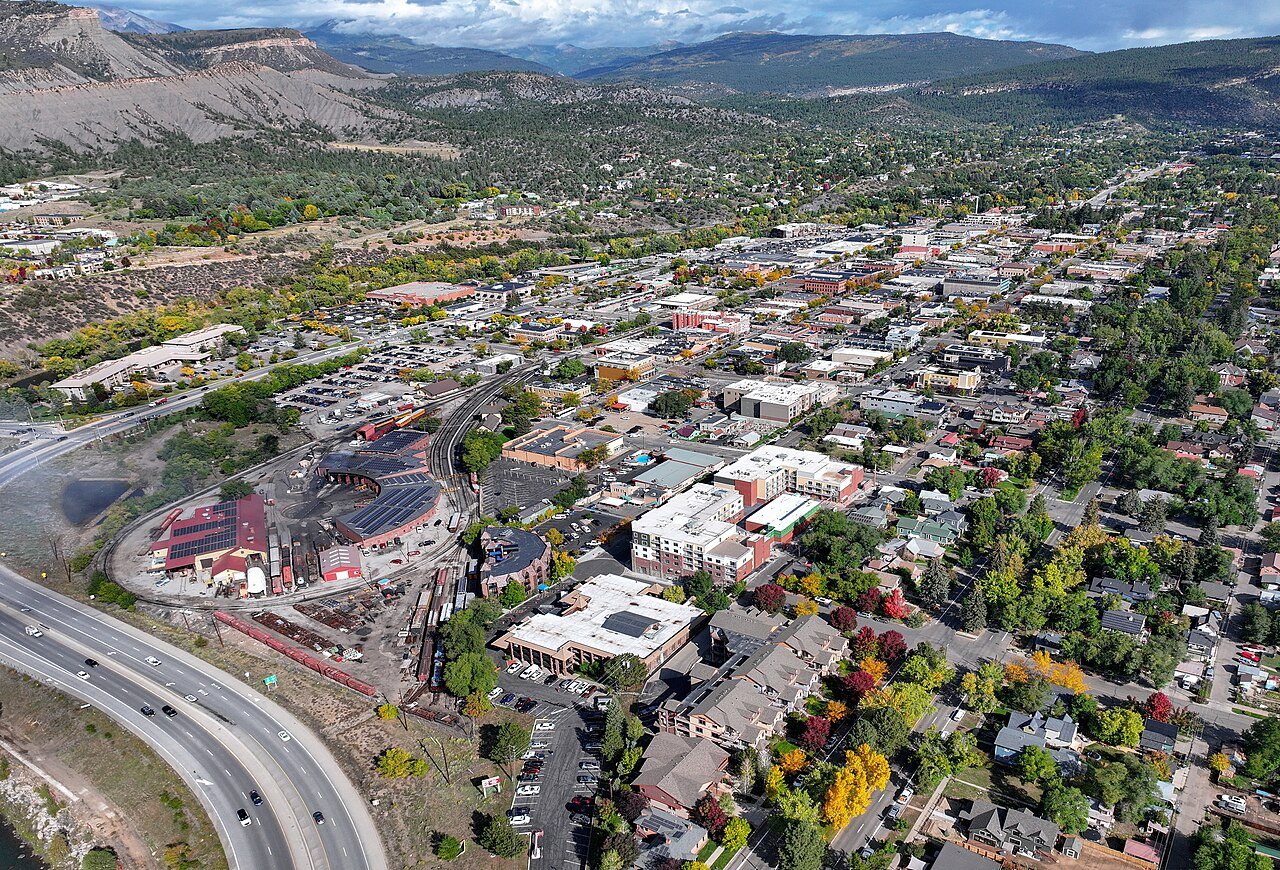
Photo: Quintin Soloviev · CC BY 4.0. Image resized for web display.

- Region
- Southwest Colorado / Animas Valley
- Road junction
- US 160 and US 550
- Nearby airport
- Durango–La Plata County Airport, southeast of town
- Best base for
- Rail excursions, river recreation and San Juan Mountain day trips
Start here
Get to know Durango
Durango gives a southwest Colorado trip a useful mix of town time, river access and mountain excursions. The Animas River runs through the city, and its shared-use trail lets you start exploring without first driving to a distant trailhead. The railroad adds a very different way to see the surrounding country, while the mountains north of town open up skiing, Nordic outings and longer summer adventures.
Choose the kind of day you want before choosing the route. A river walk and a short downtown visit fit naturally together. A railroad excursion, a guided rafting trip or a ski day deserves a larger block of time. The high passes, trail systems and reservoirs also follow different seasonal patterns. A warm afternoon beside the Animas does not mean a mountain trail is clear or that every lake is open. That variety is part of Durango’s appeal, provided the itinerary leaves room for the conditions.
Choose your stops
Things to do in Durango
Browse the highlights, open a guide or save a stop for your trip.
 Open Road ColoradoExplore Durango
Animas River Trail
Walk or ride a chosen section rather than feeling obliged to cover the entire corridor.
More about this stop
Walk or ride a chosen section rather than feeling obliged to cover the entire corridor. The paved shared-use trail connects parks, art and river views. Public fishing and river-access points have their own facilities; remain on established routes instead of creating a new path to the bank.
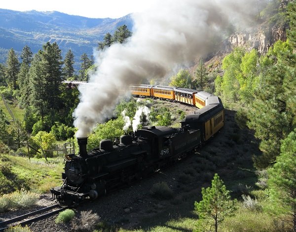
Durango & Silverton railroad
Choose the excursion for the season and the experience you want.
More about this stop
Choose the excursion for the season and the experience you want. The winter Cascade Canyon trip is a round-trip outing from Durango, not the same itinerary as a summer visit to Silverton. An accessible coach is available on specified services but requires advance arrangements because capacity is limited.
Open Road ColoradoExplore DurangoAnimas River recreation
Guided rafting, riverside fishing and watching paddlers from land are different ways to enjoy the same river.
More about this stop
Guided rafting, riverside fishing and watching paddlers from land are different ways to enjoy the same river. Select the exact reach with a qualified operator if you are unfamiliar with moving water. The presence of an urban trail does not make every rapid or riverbank suitable for beginners.
Open Road ColoradoExplore DurangoHorse Gulch and local trail networks
Durango’s trail systems provide a wide range of walking and mountain-bike options.
More about this stop
Durango’s trail systems provide a wide range of walking and mountain-bike options. Consult the current map for a route that matches the group. Some connected areas close for winter wildlife, so do not assume a trail remains available simply because its lower access looks dry.
Open Road ColoradoExplore DurangoLake Nighthorse
Use the city’s recreation information to plan a seasonal lake day.
More about this stop
Use the city’s recreation information to plan a seasonal lake day. The developed area includes an accessible fishing dock near the boat ramp, and boating brings inspection and access requirements. The 2026 winter wildlife closure starts November 16; check the next season rather than treating the lake as a year-round recreation site.
Open Road ColoradoExplore DurangoPurgatory and Durango Nordic
For winter, decide between a lift-served ski day and a Nordic or snowshoe outing.
More about this stop
For winter, decide between a lift-served ski day and a Nordic or snowshoe outing. These are north-of-town mountain excursions with their own operating schedules. Adaptive Sports Association offers winter programs at Purgatory; arrange the specific equipment and instruction before traveling.
6 places to explore
Location photographs: Branded illustrations identify stops without a location photo.
Four seasons, different plans
When to visit
Spring in Durango
Build around the river corridor and check which higher trails are ready. Wildlife closures can remain in place even when the weather feels like riding season. Spring runoff changes river conditions, so a rafting trip should be selected for that day’s flows and the group’s experience.
Summer in Durango
Choose a river day, railroad outing and mountain day as separate experiences. Carry a fallback plan for high-country weather and leave transition time between activities. Lake recreation depends on the city’s operating calendar and any inspection or launch requirements.
Fall in Durango
The Animas corridor offers water and cottonwood scenes, while the higher country changes on a different schedule. A slow walk can produce better photographic opportunities than racing between overlooks. Confirm seasonal service and trail access before building a day around a particular stop.
Winter in Durango
Use the railroad, Purgatory and Durango Nordic as distinct options, then choose local walks from trails that remain open. Winter wildlife closures protect important habitat around the city. Do not route a hike through a closed network to reach a viewpoint.
Go a little deeper
Choose your kind of adventure
Skiing & winter recreation
Plan winter outings around Durango, with activity choices, seasonal access and practical resources.
Read the guideHiking & biking
Explore hiking and biking around Durango, with route choices, access details and official trail resources.
Read the guideRafting & fishing
Plan rafting and fishing near Durango, with river choices, seasonal access and current planning resources.
Read the guideWildlife & fall photography
Find wildlife and landscape photography ideas around Durango, with seasonal planning and responsible viewing advice.
Read the guidePlan the drive
Getting to Durango
Choose your starting point, then open the current route and road conditions.
From Denver
6.5 hours Published planning estimate
Published planning estimate. Estimate source
Weather, closures and traffic can change the drive. Town map pins are not parking entrances.
From Colorado Springs
6 hours Published planning estimate
Published planning estimate. Estimate source
Weather, closures and traffic can change the drive. Town map pins are not parking entrances.
From Pueblo
Check live directions
Use your departure time and exact starting point for the current route and drive time.
Weather, closures and traffic can change the drive. Town map pins are not parking entrances.
From Fort Collins
Check live directions
Use your departure time and exact starting point for the current route and drive time.
Weather, closures and traffic can change the drive. Town map pins are not parking entrances.
From Grand Junction
Check live directions
Use your departure time and exact starting point for the current route and drive time.
Weather, closures and traffic can change the drive. Town map pins are not parking entrances.
From Ouray
2 hours Published planning estimate
Published planning estimate. Estimate source
Weather, closures and traffic can change the drive. Town map pins are not parking entrances.
From Telluride
2.5 hours Published planning estimate
Published planning estimate. Estimate source
Weather, closures and traffic can change the drive. Town map pins are not parking entrances.
Local transportation and accessibility
Durango sits at US 160 and US 550. The tourism bureau’s mileage chart offers useful broad planning estimates: about 6.5 hours from Denver and 6 hours from Colorado Springs. Those are normal-condition baselines, not live traffic estimates. The northern US 550 route crosses high mountain passes; the route from Denver via US 285 and US 160 also needs a road and weather check. Keep a regional airport transfer separate from the long-distance drive calculation.
Reserve the experience you need
The river-trail resources identify accessible fishing piers and developed access points, but each activity still needs its own check. The railroad’s accessible coach has limited space and must be requested in advance. Adaptive Sports Association offers skiing and other recreation programs. Confirm the route surface, boarding arrangements and equipment with the provider rather than assuming a general access label covers the entire day.
Official planning information · Additional official guidance · Additional official guidance
View town areaMake a weekend of it
Durango events
Choose a month or jump to the next announced event. Select an event date for its official program.
Event calendar
Select an event date to open its official program. Times are on the organizer’s program.
Confirmed date ranges only. Selected-performance seasons are listed below the calendar without daily event markers. Schedules can change; confirm with each organizer.
Dates checked November 14, 2026. Daily programs and admission are set by the organizers.
Build a longer trip
Keep exploring Colorado
These are separate destinations. Check driving routes and allow time between them.
Your Open Road Bucket List
Save a place. Plan the trip.
0 saved stops in this browser.
Sources, photo credits and map details
Planning information checked November 14, 2026. Follow the linked operators and land managers for changes.
- Durango Cowboy Gathering
- Durango & Silverton Railroad: Accessible coach
- Durango & Silverton Railroad: Cascade Canyon winter train
- Visit Durango: Animas River
- Visit Durango: Animas River Trail
- Visit Durango: Winter planning
- Visit Durango: Mileage chart
- Visit Durango: Birding and wildlife
- City of Durango: Lake Nighthorse
- City of Durango trails
- Iron Horse Bicycle Classic: Road race
- www.openstreetmap.org
- www.openstreetmap.org
- Purgatory: Durango Nordic Center
- Purgatory: Adaptive Sports Association
- www.wikidata.org
- www.wikidata.org
- 2025 Census Gazetteer: Colorado places
Photo credits
- Photo: Quintin Soloviev · CC BY 4.0. Image resized for web display.
The destination map pin represents the town area. It is not a trailhead, parking entrance or route instruction. Specific attraction points are recorded only when a source can be verified. Use the official access information before setting out. OpenStreetMap-derived attraction points, where used, are credited to OpenStreetMap contributors under the ODbL.