
Upper Gunnison Valley
Crested Butte, Colorado
Crested Butte is a good place to slow down and give the surrounding valleys their own days.
Saved in this browser. View your list in the Visitor Center.

Photo: Helimedic39 · CC BY-SA 3.0. Image resized for web display.

- Best for
- Mountain biking, wildflowers, skiing, Nordic trails and fall scenery
- Suggested stay
- Three or more nights for separate town, trail and valley days
- Main approach
- US 50 to Gunnison, then CO 135 north
- Know the difference
- Crested Butte is the historic town; Mt. Crested Butte contains the resort base
Start here
Get to know Crested Butte
Crested Butte is a good place to slow down and give the surrounding valleys their own days. The historic town, the resort community of Mt. Crested Butte and the river country around Almont are connected, but they are not the same place. Knowing that difference makes it easier to choose a base, a bus route and an outing that fits your time.
Mountain biking, skiing and wildflower walks each offer a different way to explore the valley. In warmer months, start with the Lower Loop or another town-accessible route before heading for a longer ride or high-country hike. In winter, choose between resort skiing, Nordic trails and a simple day in town rather than assuming every summer road stays open.
The distance from the Front Range rewards a longer visit. It does not guarantee empty trails, especially during wildflower season and fall color. Plan popular dates early, use the local trail reports, and leave room for weather to decide which valley you explore next.
Keep the town in the itinerary
Crested Butte’s older buildings and mining heritage are part of the visit, not simply a backdrop on the way to the trails. Retain time for the town’s museum and local arts programming. The surrounding valleys have living communities, ranches, research areas and protected land as well as recreation. In particular, do not approach Gothic as if every building or meadow were an unrestricted ghost-town attraction; follow the current visitor instructions and stay on public routes.
Official planning information · Additional official guidance
Choose your stops
Things to do in Crested Butte
Browse the highlights, open a guide or save a stop for your trip.
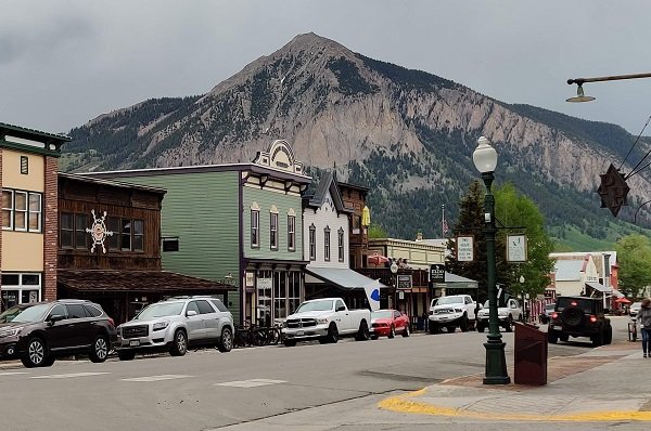
Historic Crested Butte
Spend time on the town streets and at cultural stops before driving farther into the valleys.
More about this stop
Spend time on the town streets and at cultural stops before driving farther into the valleys. Walking and local buses can cover much of a town day.

Crested Butte Mountain Resort
Located in Mt.
More about this stop
Located in Mt. Crested Butte, with terrain that ranges from learning areas to serious expert skiing. Check the operational trail map and lesson meeting place.
 Open Road ColoradoExplore Crested Butte
Lower Loop
A town-connected hiking and biking choice through protected valley land.
More about this stop
A town-connected hiking and biking choice through protected valley land. Follow the land trust’s route guidance and remember that winter use is managed differently.
Open Road ColoradoExplore Crested ButteLupine and Gunsight Connector
A riding option above the Slate River Valley.
More about this stop
A riding option above the Slate River Valley. Use CBMBA’s directions and status, and plan the whole loop rather than assuming a short visible section is the complete ride.
Open Road ColoradoExplore Crested ButteCrested Butte Nordic
A winter trail network with current grooming information and passes.
More about this stop
A winter trail network with current grooming information and passes. Use designated routes and the correct pass for your outing.
Open Road ColoradoExplore Crested ButteAlmont and the Taylor River
Make this a separate regional day for guided water recreation or fishing.
More about this stop
Make this a separate regional day for guided water recreation or fishing. The meeting point may be south of Crested Butte rather than in town.
Open Road ColoradoExplore Crested ButteBlue Mesa and Curecanti
A larger reservoir landscape west of Gunnison, useful for a separate fishing or water-focused day.
More about this stop
A larger reservoir landscape west of Gunnison, useful for a separate fishing or water-focused day. Check NPS access and current conditions before setting out.
7 places to explore
Location photographs: Branded illustrations identify stops without a location photo.
Four seasons, different plans
When to visit
Winter in Crested Butte
Resort skiing and groomed Nordic trails anchor the season. Use the Gunnison approach and current road reports; summer shortcuts can be closed.
Spring in Crested Butte
Snowmelt creates a variable transition. Check lower-valley alternatives and do not widen muddy trails to get around wet sections.
Summer in Crested Butte
Wildflowers and high-country riding draw visitors. Match the trail to your ability and use current CBMBA conditions before selecting a route.
Fall in Crested Butte
Aspen groves around the valleys offer several options. Choose by current color and road conditions, not a promised peak weekend.
Go a little deeper
Choose your kind of adventure
Skiing & winter recreation
Plan winter outings around Crested Butte, with activity choices, seasonal access and practical resources.
Read the guideHiking & biking
Explore hiking and biking around Crested Butte, with route choices, access details and official trail resources.
Read the guideRafting & fishing
Plan rafting and fishing near Crested Butte, with river choices, seasonal access and current planning resources.
Read the guideWildlife & fall photography
Find wildlife and landscape photography ideas around Crested Butte, with seasonal planning and responsible viewing advice.
Read the guidePlan the drive
Getting to Crested Butte
Choose your starting point, then open the current route and road conditions.
From Denver
About 4.5 hours Published planning estimate
US 285, US 50, then CO 135 Estimate source
Weather, closures and traffic can change the drive. Town map pins are not parking entrances.
From Colorado Springs
Check live directions
Use your departure time and exact starting point for the current route and drive time.
Weather, closures and traffic can change the drive. Town map pins are not parking entrances.
From Pueblo
Check live directions
Use your departure time and exact starting point for the current route and drive time.
Weather, closures and traffic can change the drive. Town map pins are not parking entrances.
From Fort Collins
Check live directions
Use your departure time and exact starting point for the current route and drive time.
Weather, closures and traffic can change the drive. Town map pins are not parking entrances.
From Grand Junction
Check live directions
Use your departure time and exact starting point for the current route and drive time.
Weather, closures and traffic can change the drive. Town map pins are not parking entrances.
From Colorado Springs airport
About 4 hours Published planning estimate
CO 115, US 50 and CO 135; check current conditions Estimate source
Weather, closures and traffic can change the drive. Town map pins are not parking entrances.
Local transportation and accessibility
For the principal paved approach, reach Gunnison on US 50 and follow CO 135 north. The Colorado Tourism Office describes the Denver route via US 285, US 50 and CO 135. Seasonal mountain roads are recreation routes or summer alternatives, not dependable winter approaches.
Check Gunnison Valley RTA and Mountain Express for current routes linking Gunnison, Crested Butte and Mt. Crested Butte. A free bus network does not mean every trailhead has bus access.
Arrange adaptive recreation before arrival
The Adaptive Sports Center in Mt. Crested Butte is a strong starting point for an activity planned around individual needs. Contact the center directly about equipment, transfers, program suitability and reservations. For an independent outing, confirm the actual surface and slope of the selected route with its manager. A summer bike path, a snow-covered Nordic trail and a resort base area can present very different access conditions even when they appear close together on a map.
Official planning information · Additional official guidance · Additional official guidance
View town areaMake a weekend of it
Crested Butte events
Choose a month or jump to the next announced event. Select an event date for its official program.
Event calendar
Select an event date to open its official program. Times are on the organizer’s program.
Confirmed date ranges only. Selected-performance seasons are listed below the calendar without daily event markers. Schedules can change; confirm with each organizer.
Also worth planning around
- Crested Butte Film Festival Next dates on the organizer’s website
Dates checked November 14, 2026. Daily programs and admission are set by the organizers.
Build a longer trip
Keep exploring Colorado
These are separate destinations. Check driving routes and allow time between them.
Your Open Road Bucket List
Save a place. Plan the trip.
0 saved stops in this browser.
Sources, photo credits and map details
Planning information checked November 14, 2026. Follow the linked operators and land managers for changes.
- Crested Butte Land Trust Lower Loop
- CBMBA current trail conditions
- CBMBA Lupine and Gunsight Connector
- Crested Butte Wildflower Festival 2027
- Crested Butte town-accessible trails
- Responsible Gunnison Valley travel
- Crested Butte fall planning
- Gunnison Crested Butte winter guide
- Gunnison Crested Butte access
- Taylor and Gunnison river boating
- Gunnison Crested Butte hikes
- Adaptive Sports Center
- Adaptive Sports Center arrival
- Crested Butte Film Festival organizer
- CB Nordic current trail status
- Colorado Tourism Office Crested Butte access
- Crested Butte Arts Festival 2027
- NPS Curecanti fishing
- Crested Butte Mountain Resort base guide
- www.wikidata.org
- www.wikidata.org
- www.wikidata.org
- www.wikidata.org
- 2025 Census Gazetteer Colorado places, internal representative points
Photo credits
- Photo: Helimedic39 · CC BY-SA 3.0. Image resized for web display.
The destination map pin represents the town area. It is not a trailhead, parking entrance or route instruction. Specific attraction points are recorded only when a source can be verified. Use the official access information before setting out. OpenStreetMap-derived attraction points, where used, are credited to OpenStreetMap contributors under the ODbL.
Pingback: Wildlife & Fall Photography Around Crested Butte
Pingback: Fishing & Rafting Around Crested Butte and Gunnison
Pingback: Hiking & Biking Around Crested Butte
Pingback: Skiing & Winter Recreation Around Crested Butte